My name is Tomás Cuevas López. I'm a coastal engineer from Chile, and a second-year MSc student in the Coastal and Computational Hydraulics Team (CCHT) at North Carolina State University. I'm passionate about coastal processes, open-source, and programming.
I did my undergrad at the Faculty of Physical and Mathematical Sciences (FCFM) at the University of Chile in Civil Engineering. For my undergraduate thesis, I developed a set of Python scripts to validate and calibrate deep water waves using satellite altimetry.
Then, I joined PRDW, where I worked for almost six years. In this period, I gained experience in Python programming, machine learning, geospatial analysis, and numerical modeling of coastal processes. I worked in an extensive range of studies, such as tsunami modeling and computational fluid dynamics (CFD).
During my MSc, I have been working on a software to improve storm surge hazard communication and on a deep learning model to quickly predict high-resolution maps of storm-driven coastal flooding using the storm track and the astronomical tides as inputs.
What I do
The main goal of my research at NC State has been to improve the predictions and communication of storm-driven coastal flooding. Forecasters use models like ADCIRC to simulate the storm's effects during tropical cyclones. These simulations can take from 1 to 3 hours in high-performance computing systems. Typically the meshes used for real-time forecasting sacrifice resolution to reduce model run-time. We developed a set of Python scripts to downscale or increase the resolution of the flooding maps as a postprocessing step in nearly 5 minutes. The software, named Kalpana, is freely available at the CCHT Github.
At PRDW, I worked simultaneously for three teams. First, in numerical modeling of coastal processes, I specialized in hydrodynamic (2 and 3D), tsunami, sediment transport (sand and mud), and wave (phase and average resolving) modeling. I also worked with CFD models to study overtopping, run-up, and wave-structure interactions. In data science, I specialized in Python programming developing software, and applying machine learning to coastal and port engineering-related problems. Finally, in the port and harbors team, I specialized in moored vessel's dynamic response modeling and the stochastic modeling of port operations.
Coastal processes
- ADCIRC
- MIKE by DHI: SW, BW, ST, MT, HD, M3WFM, and MA.
- OpenFOAM
- olaFlow
Programming
- Python: machine learning, geospatial analysis, and data visualization.
- Matlab
- Octave
Numerical meshes
- MIKE Zero Mesh Generator
- Oceanmesh (Python version)
- SMS surface-water modeling system
- blockMesh (OpenFOAM)
- snappyHexMesh (OpenFOAM)
Research
Kalpana - Downscaling of Peak Storm Surge Maps
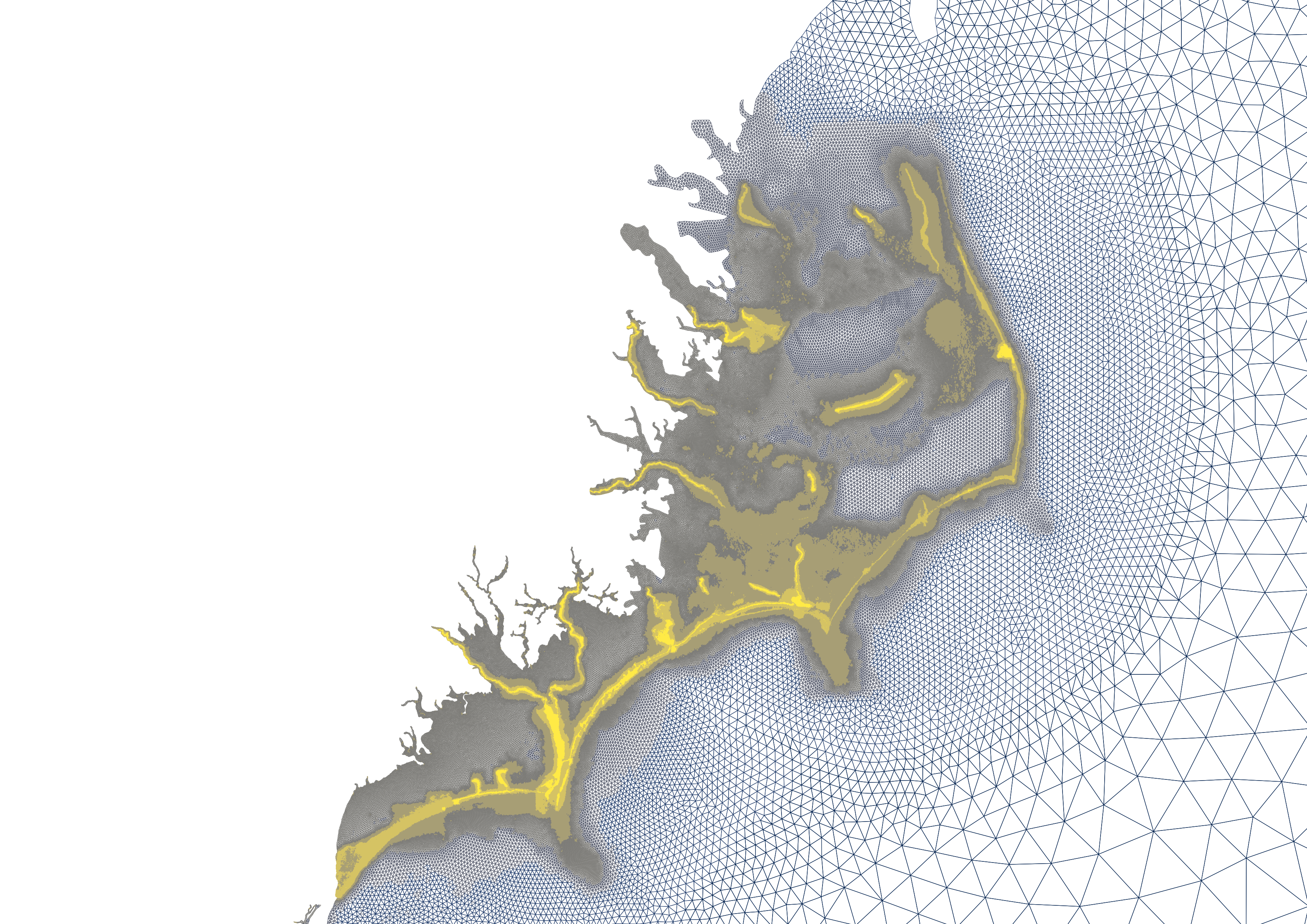
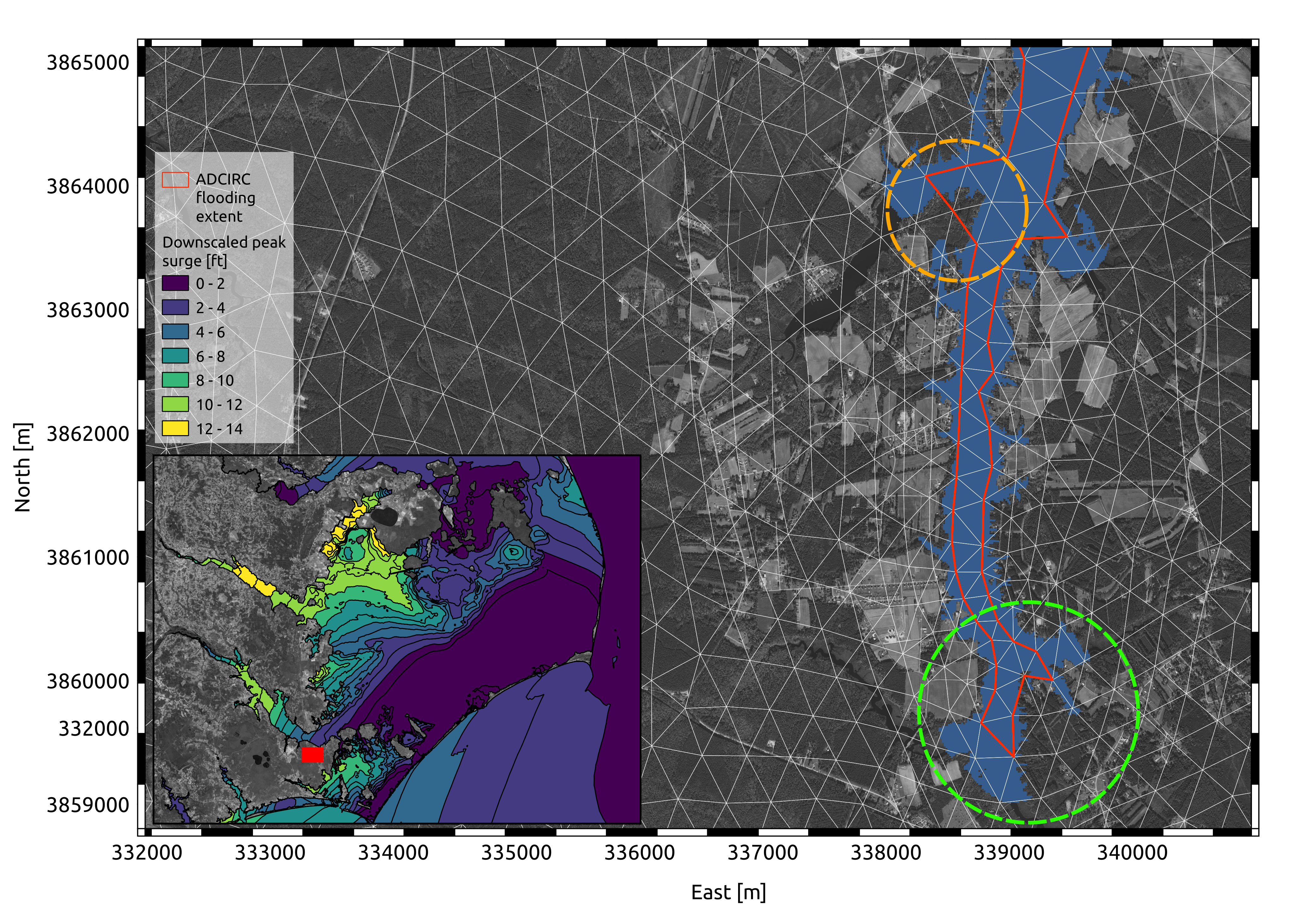
Kalpana is a highly modularized and optimized Python module to convert ADCIRC time-constant and -varying outputs to geospatial vector formats and to downscale the maximum water elevation *maxele.63.nc* output. Kalpana reprojects the unstructured *maxele.63.nc* to a constant and high-resolution DEM and downscales the peak storm surge by considering small-scale topographic and bathymetric features. The figure below shows an example of a downscaled peak storm surge map downscaled. You can find more information, examples and a step-by-step guide to install kalpana on: https://github.com/ccht-ncsu/Kalpana.
The smaller panel shows the raw peak surge for the North Carolina Coast. The main panel shows a close-up view of the Neuse River in the Outer Banks to appreciate the downscaling effect. The red line delineates the boundary of the raw ADCIRC peak surge. The green circle highlights an area where the peak surge is spatially expanded along neighbor cells with an elevation below the peak surge level. The orange circle points to a dry area inside the raw ADCIRC peak surge boundary where Kalpana removed "fake" wet cells with ground elevation above the water level.
Prediction of High-Resolution Maps of Storm-driven Coastal Flooding using Deep Learning
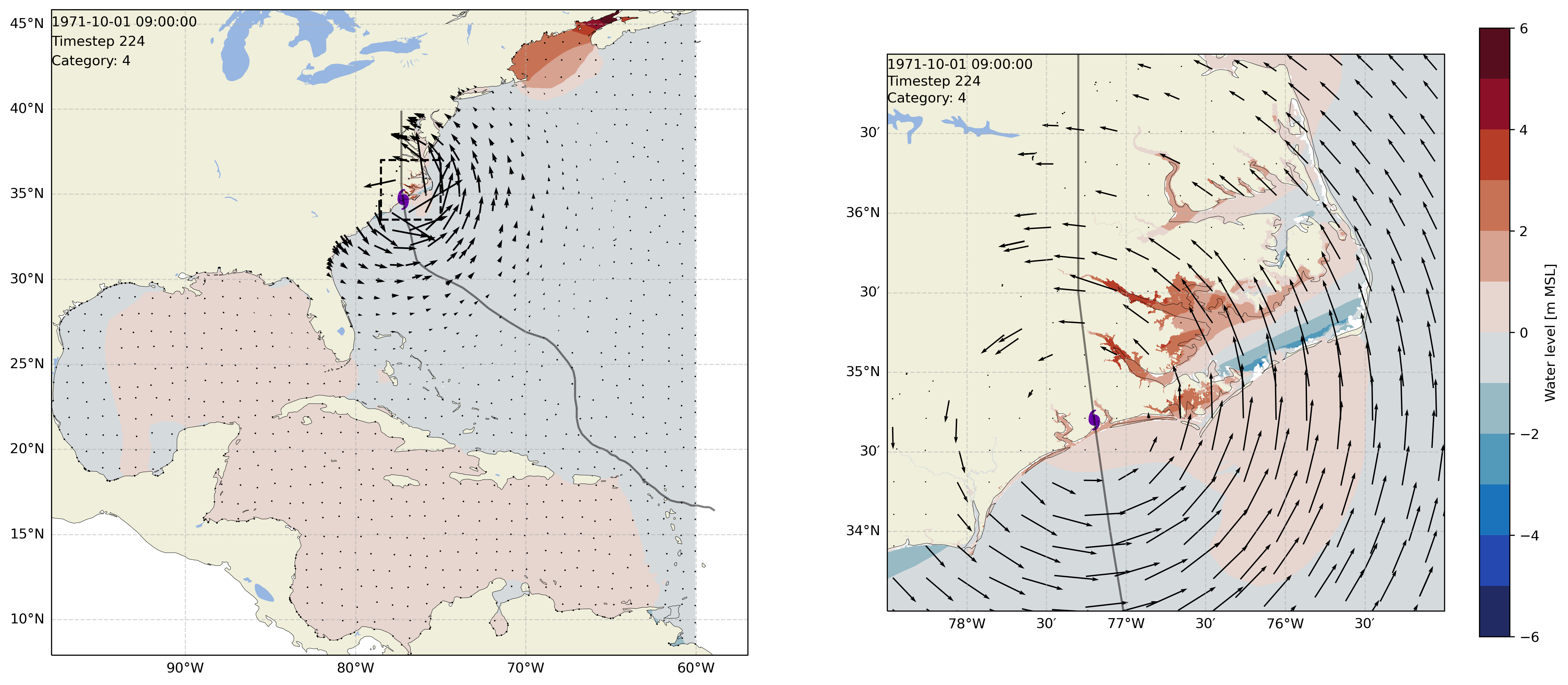
In this research, we propose a deep learning method for forecasting high-resolution maps of peak hurricane-driven coastal flooding for North Carolina, considering astronomical tides and storms of any duration. The algorithm is primarily based on Long Short Term Memory units to handle the time evolution of the hurricane and in 2D convolution layers to address the geospatial variability of the flooding. We used a synthetic database of tropical cyclones based on historical data to generate the training library, with 10,000 years of information in the North Atlantic Ocean and more than 100,000 storm tracks. First, we reduced the number by selecting a subset of tracks that passed close to North Carolina. Then, applying the maximum dissimilarity algorithm, we chose 1,000 storms representing the entire distribution of track parameters, taking into account the extreme values. Next, we simulated the 1,000 tracks using ADCIRC with a random astronomical tide. Finally, using Kalpana , we downscaled the peak surge to a higher and constant resolution. The proposed model can predict high-resolution maps of storm-driven coastal flooding for North Carolina from a time series of the following parameters: coordinates of the storm eye, maximum wind speed, minimum pressure, radius to maximum wind speeds, and astronomical tides.
The plot shows the propagation of a tropical cyclone along with the wind field and the variation of the water level. The left panel shows the full North Atlantic ocean basin and the right panel a close-up view of North Carolina, where this study is focused.
Consulting
The content showed in this sections is intelectual property of PRDW, it was developed Tomás and PRDW engineers.
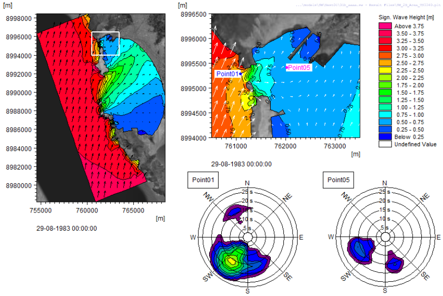
Local Wave Climate - Spectral Wave Modeling
The plot corresponds to an output of a nested spectral wave model. The site is a sheltered bay from South America. The left panel shows the full domain, the bay has a few inlets that allows the waves to propagate. The upper right right panel shows a close-up view of the points of interest, and the lower panel, spectral plots at Point01 and Point05. The Point05 spectral plot shows there is incident energy from the north inlet, but also from the bay.
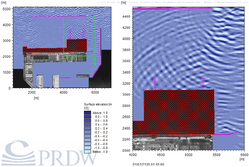
Port Agitation - Phase resolving Wave Modeling
The plot corresponds to an output of a Boussinesq wave model. In this study we studied the agitation inside the port basin and the dynamic response of moored vessels for different port and breakwater layouts.
Overtopping - Computational Fluid Dynamics Model
For this study we used olaFlow to simulate the interaction of waves and a multi-layer porous breakwater. The animation shows the waves overtopping the structure. The bottom panels show the overtopping flow rate and the Crown's wall horizontal and subpressure forces.
Counting Beach Users - Deep Learning
This was a personal R&D project done by Tomas driven by his interest in Computer Vision and Machine Learning. The goal was to develop a Neural Network capable of counting beach users during the COVID-19 pandemic to help Chilean municipalities avoid over crowding their beaches.
Contact Information
If you have any questions about my work or would like to chat, please feel free to contact me!